Active vacation
Via Ferrata on Mount Mučanj

Via Ferrata is located on Mučanj mountain. A well-marked path leads to the Via Ferrata. There are signposts from the main road that lead travelers exactly to the start of the via ferrata. It is about 27 km or 35 minutes’ drive from the center of Ivanjica.
Using the Ferrata is free. In the following period, the Tourist Organization of the Municipality of Ivanjica will provide the service of hiring a guide trained in Via Ferrata and renting the necessary certified equipment necessary for using Via Ferrata.
Immediately before entering the via ferrata, there is an information board with detailed features of the via ferrata, pictures of the necessary equipment for using the via ferrata and potential dangers that may befall users of the via ferrata.
Cycling

Cycling has gained increasing popularity in the Ivanjica municipality, where it is especially practised by those who love to combine holiday and adrenaline sports. Knowing this, it is hardly surprising that the mountain parts of the Ivanjica attract lovers of mountain biking, as a specific combination of cycling, mountaineering and adventure. The mountain biking routes are scattered around the most beautiful part of the mountains of Golija, Javor and Mučanj. In addition to this, some of the marked trekking routes are also used for mountain biking. The growing number of cyclists visiting or pasing through the region of Ivanjica has provided additional motivation to complete the work of marking several cycle paths, complete with benches where cyclists can make a break and enjoy the vistas of the surrounding countryside. Don’t waste another moment – set your gears and use your pedals to join your friends for a brand new adventure on the cycle routes of Ivanjica.
Walking ant trekking/ mountain climbing, ZIP Line
Walking and trekking

Walking and trekking as part of an active holiday have recently gained considerable popularity in the tourist offer of Ivanjica. In the territory of the Ivanjica municipality Ivanjica there are numerous marked routes for walking and trekking – owing to the efforts of the “Golija” mountaineering club and the “Stari Vlah” extreme sports club, these have been made accessible to lovers of walking and trekking. For additional safety, the “Golija” mountaineering club has a licensed mountain guide. Apart from the regular tours, the club offers a number of attractive guided programmes and tours suitable for beginners. The marked routes pass through picturesque landscapes of the Ivanjica municipality. Intersecting the slopes of Golija, Javor and Mučanj, the routes take the visitors to the surrounding beauty spots, as well as cultural and historic places of interest. As a great Serbian scientist once said, geography is best learned walking – therefore, we warmly recommend a walking study tour of the beautiful areas around Ivanjica, taking you through fairy-tale woods and vast pastures, crystal clear rivers and cool brooks, where delicious forest fruits can be picked everywhere you go.
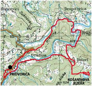
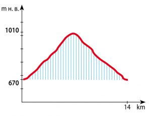
The route is 14 km long and it normally takes around four and a half hours of moderately-paced walk to cover it from the start to finish, with the height difference of 340 m. The starting point is the Pridvorica monastery, at 670 m above the sea (the monastery dates back to 12th century, and was built at the same time as the Studenica monastery). From here, the path follows the Studenica river for about 2 kilometres, to the point where the path branches off leading to the Košanin Lakes (1000 above the sea level), a place that gave rise to many legends (more about these lakes can be found in the brochure titled “Golija Lakes – Nature’s Gift on the Top of West Serbia”, published by the Tourist Organisation of the Ivanjica municipality). The lakes are known for an unusual and as yet unexplained phenomenon: while they are virtually dry during the rainy season, fill with water during droughts (reaching depth of 5-8 m). This is the site of the so-called “Prayer” spot (dedicated to Saint Elijah, the spot represent the site of a former church and a place of one-time large traditional gatherings of the local people). This is the final destination of the route, a picnic area with nice benches and tables, where walkers can take a rest at 1010 m above the sea level. On the return, the route follows the same path for some time, before it turns along the Studenica river, leading to the place where it receives the Braduljica river. This is the site of a natural hatchery of several fish species (huchen, brown trout and grayling), unique in Seerbia. From here, the route passes across the hill of Gradina and goes back to the starting point at the village of Pridvorica, where visitors can take a longer rest and spend some time relaxing and socialising.

ROUTE 1: The route is 9.100 m long and it normally takes between three and four hours of moderately-paced walk to cover it from the start to finish, with the height difference of 425 m. The starting point is the Golijska river, from where the path leads towards Preko brdo and further on, to Golija’s highest peak, Jankov kamen (1833 m above sea level), before taking the descent to Babića livade and further on, to the starting point at Golijska reka (1408 m above sea level).
ROUTE 2: The route is 10.500 m long and it normally takes around five hours of moderately-paced walk to cover it from the start to finish, with the height difference of 340 m. The starting point is the Golijska river, from where the path leads towards Hajdučka voda and further on across Tašove livade and Pašina česma to the Bojovo brdo pak (1748 m above sea level). From here, the route goes down past the Milošica spring, all the way to the starting point at Golijska reka (1408 m above sea level).
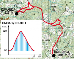
ROUTE 1: The route is 7.740 m long and it normally takes around three hours of moderately-paced walk to cover it from the start to finish, with the height difference of 550 m. The starting point is “Vila Avamović” in the village of Kumanica, from where the path leads over Mojsilova ravan, past the Đunova voda spring, Kalilo and the Okruglica “Heaven’s Teardrop” lake, to the peak plateau at 1495 m above sea level (more information can be found in the brochure titled “Golija Lakes – Nature’s Gift on the Top of West Serbia”, published by the Tourist Organisation of the Ivanjica municipality), where it joins Route No. 2. From this point, it is possible to continue the walk along Route 2, or go back following the same route.
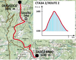
ROUTE 2: The route is 7.000 m long and it normally takes around two and a half hours of moderately-paced walk to cover it from the start to finish, with the height difference of 165 m. The starting point is at the house of the “Golija” mountaineering club at Dajića brdo (lying at 1330 m above seal level). After about half an hour’s walk through the wood, the path branches off to the right and continues along the new forest path. Going further on past the hunters’ tree stand, it eventually reaches the Okruglica “Heaven’s Teardrop” lake and the mountain peak (1495 m above seal level) (more information can be found in the brochure titled “Golija Lakes – Nature’s Gift on the Top of West Serbia”, published by the Tourist Organisation of the Ivanjica municipality), where it joins Route No. 1. From this point, it is possible to continue the walk along Route 1, or go back following the same route.
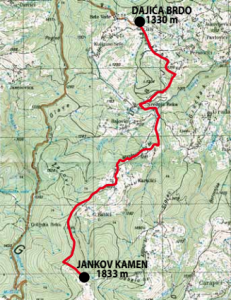
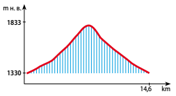
The route is 14,6 km long and it normally takes around four and a half hours of walk to cover it from the start to finish, with the height difference of 503 m and average incline of 8%. Starting from the campsite at Dajića brdo, the path goes through the Srednja reka precinct and continues past Maslovarića brdo and Karalići, over Babića brdo and along the Golijska river. Continuing past the skiing track, it reaches Jankov kamen (1883 m above seal level), the highest peak of the Golija mountain. The marking of the route was performed by the “Stari Vlah” Club for Extreme Spots from Ivanjica in parthership with the Golija Nature Park and with the support of the Ministry of Youth and Sport of the Republic of Serbia and the Municipality of Ivanjica Office for the Young in Ivanjica.
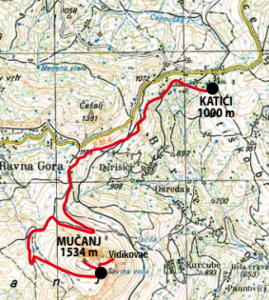
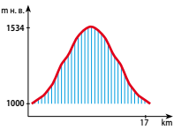
The route is 17 km long and it normally takes between four and five hours of moderately-paced walk to cover it from the start to finish, with the height difference of 534 m. Starting from the village of Katići, the path first goes along the regional road for about 1 kilometre, before it branches off towards the Mučanj mountain and continues to its highest peak, Jerinin grad (1534 m above seal level), with the unreal breathtaking vista of the surrounding area. The return from Mučanj follows the same path, with a break at the Savina voda spring in Katići (1000 m above seal level). The route is suitable for trekkers of all ages, properly marked in accordance with the rules of the Mountaineering Association of Serbia (the notice board in Katići, the map of the route and the signs and markings of the mountaineering routes), adding to its appeal for tourists visiting the municipality of Ivanjica. The marking of the route was performed within the project “A road to Europe along the routes of Ivanjica”.
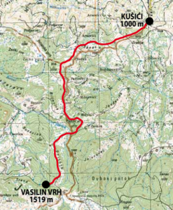
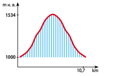
The route is 10,7 km long and it normally takes three hours of walk to cover it from the start to finish, with the height difference of 519 m. Starting from the village of Kušići at around 1000 m above the sea, the path follows the regional road to Sjenica for a while, before it merges with the old road to Javor and Sjenica, passing through the beautiful scenery and eventually reaching the mountain of Javor, the former border line between Serbia and the Ottoman Empire (until 1912) and the site of the great battles of Javor (1876-1878). The final point of the route is Vasilijin vrh peak (1519 m above seal level). The marking of the route was performed by the “Stari Vlah” Club for Extreme Spots from Ivanjica in parthership with the Golija Nature Park and with the support of the Ministry of Youth and Sport of the Republic of Serbia and the Municipality of Ivanjica Office for the Young in Ivanjica.
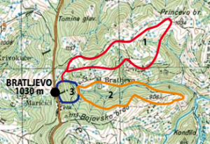
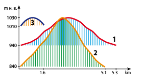
ROUTE 1: The route is 5.300 m long and it normally takes around two hours of moderately-paced walk to cover it from the start to finish, with the height difference of 90 m. Starting from the village of Bratljevo and follows the path that leads towards the local school, diverging into the pine wood some 50 metres after the start and continuing in the direction of the village of Ivkovići for about 2,5 kilometres. Reaching the crossroads, the route turns backwards and goes past the quarry, before reaching the starting point at Bratljevo, near the Ranger’s Cottage at 1030 m above the sea. The route is also known as the “family route” owing to its moderate requirements and the several nice lookouts offering beautiful views of the Golija mountain.
ROUTE 2: The route is 5.100 m long and it normally takes around two hours of moderately-paced walk to cover it from the start to finish, with the height difference of 190 m. Starting from the village of Bratljevo, the route goes past the old water spring of Zmajevac, following the forest path to Nešovića brdo, from where a gentle uphill path takes the walkers back to the spring of Zmajevac and Bratljevo (1030 m above sea level). This forest route is slightly more demanding than Route 1.
ROUTE 3: The route is 1.600 m long and it normally takes around three hours of moderately-paced walk to cover it from the start to finish, with the height difference of 20 m. Starting from the village of Bratljevo, the route goes past the school and further on through the forest, following a circular path past the water reservoir of the former Javor textile factory and the old warehouse building, before it finishes at Bratljevo (1030 m above sea level). The route is also known as the “baby route”, since it is ideal for light family walks and walks with little children.
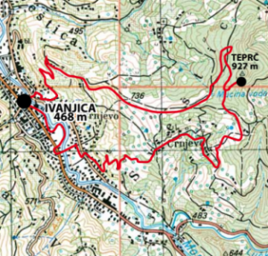
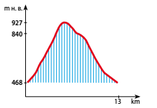
The route is 13 km long and it normally takes around four hours of moderately-paced walk to cover it from the start to finish, with the height difference of 459 m. Starting from the centre of Ivanjica, the route goes through the city park and follows the path across the Moravica river, past the Golija resort and the Javor Football Club grounds, before turning left across the Crnjevski bridge. From here, the path leads to the Teprč hill (927 m) and beyond, passing along the hill of Crnjevsko to Mućina voda springs (840 m above the sea), Sveštica and across the stone bridge (more information can be found in the brochure titled “IVANJICA – tourist guide”, published by the Tourist Organisation of the Ivanjica municipality), taking the walkers back to the starting point in Ivanjica (468 m above sea level).
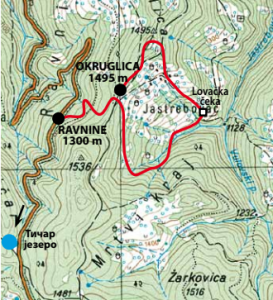
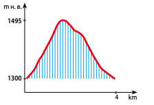
The route is 4.000 m long and it normally takes around one hour of moderately-paced walk to cover it from the start to finish, with the height difference of 195 m. Starting from the asphalt road and going in the direction of the Daićko lake in Ravnine, it turns left and continues along the Macadam road leading towards the Okruglica lake of “Heaven’s Teardrop“ (more information can be found in the brochure titled “Golija Lakes – Nature’s Gift on the Top of West Serbia”, published by the Tourist Organisation of the Ivanjica municipality). From here, the route goes through the forest before it reaches the hunters’ tree stand and merging with the paths leading on to Dajići in one direction and the village of Kumanica on the other side, past the “Heaven’s Teardrop” lake (1495 m above sea level). The return may follow the same route, or the walkers may decide to take the circular path through the wood, taking them back to the starting point of Ravnine and the asphalt road.